Proposed Area Plan Receives Third Reading
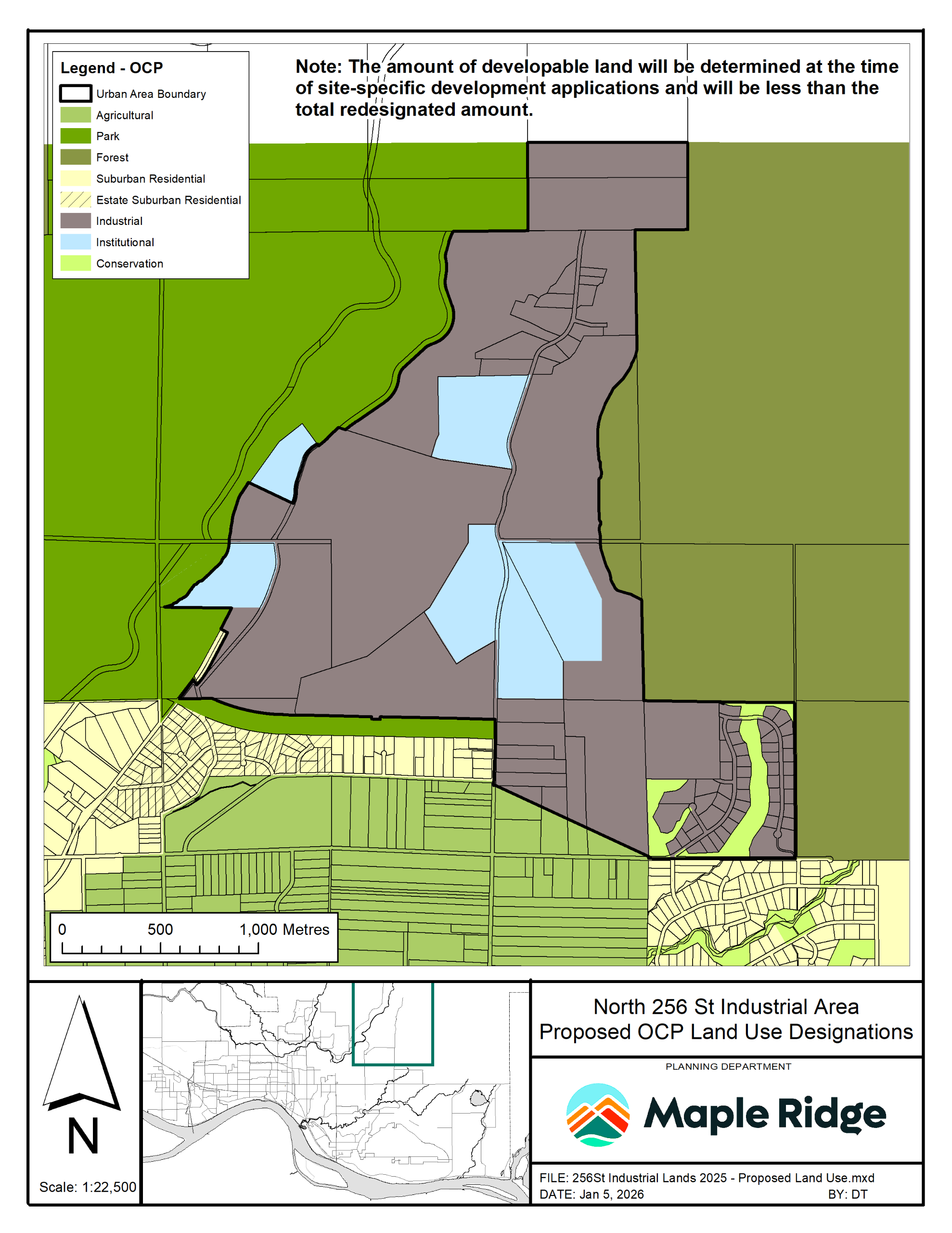
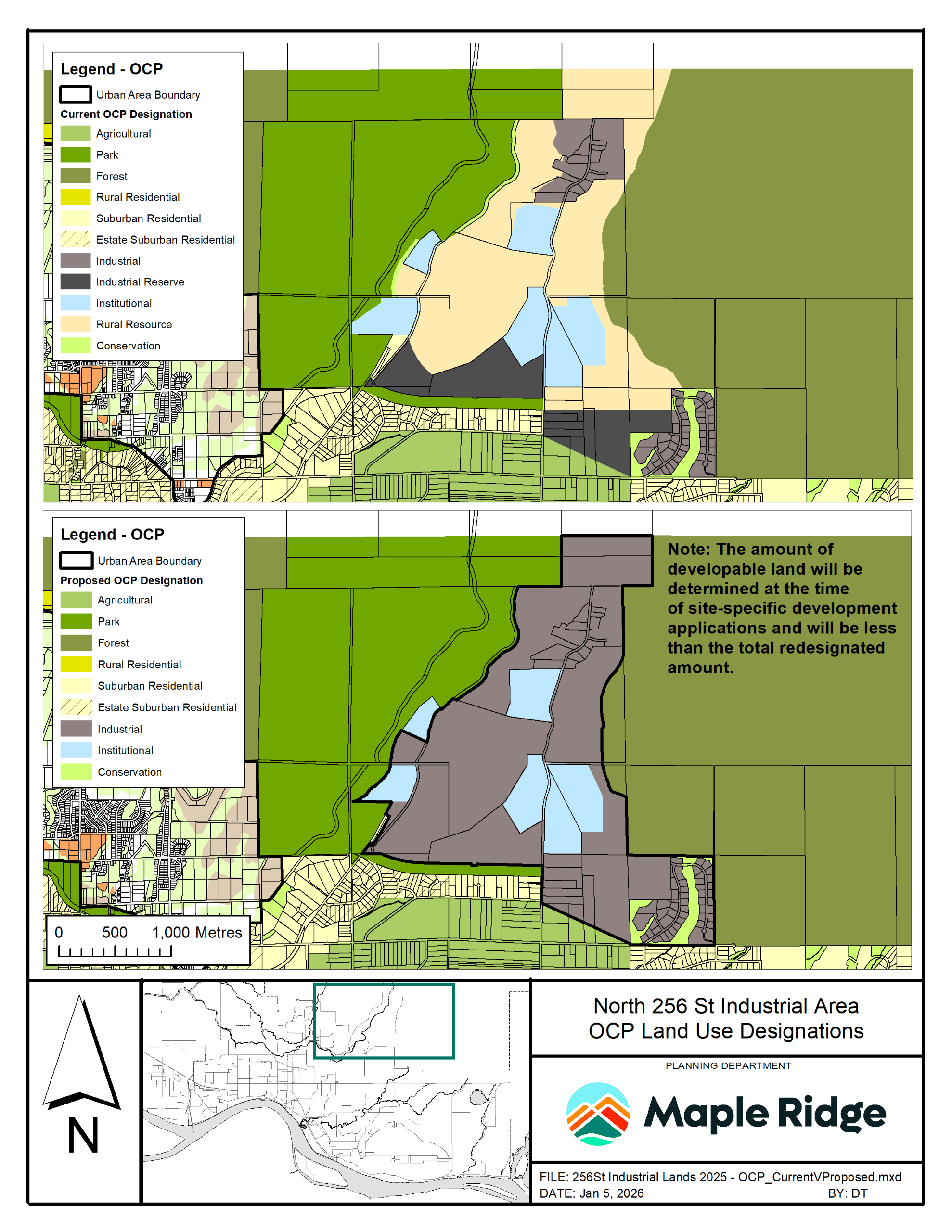
On January 27, 2026, the proposed North 256 Street Industrial Lands Area Plan and associated OCP Amending Bylaw No 8087-2026 received third reading by Council (first and second readings were received on January 6, 2026). For details, refer to the map below or the Jan 27 staff Report to Council and presentation. (linked here and in the Documents Library). For a recording of the presentation, visit MapleRidge.ca/CouncilMeetings.
Next Steps
- Regional Review: Following Council’s third reading, the proposed amendments will now be referred to Metro Vancouver for consideration and approval.
- Final Adoption: Subject to regional approvals, Council may consider final adoption of the bylaw, anticipated in mid-2026.
Sign up to receive project updates by clicking the "+Follow" button near the top of this page.
The Proposed Area Plan
The proposed area plan incorporates technical analysis and input from earlier phases of community engagement.
Supporting a Thriving Local Economy
The North 256 Street Industrial Lands, north of 128 Avenue at the end of 256 Street, are identified for expanded industrial development. The Area Plan will:
- Increase industrial land supply
- Support business investment and employment growth
- Strengthen the City’s tax base
- Align with regional and provincial economic objectives
- Coordinate transportation and infrastructure investments
Key Features of the Area Plan
- Land use framework for industrial, institutional, conservation, and supportive commercial uses
- Transportation and road network strategy, including future connections such as the Abernethy Way extension
- Servicing plans for water, sewer, and storm infrastructure
- Environmental protection measures and trails
- Urban design guidelines for high-quality, low-impact industrial development
The plan also includes OCP and Metro Vancouver Regional Growth Strategy amendments, retention of environmentally sensitive lands, and further site-specific technical reviews.
For general information on industrial lands, refer to our Industrial Lands Information Sheet.
Community Engagement
Phase 1 was open April 14 - May 19, 2025 and invited the community to provide input to help inform a proposed area plan for the North 256 St. industrial lands.
Engagement Level
The engagement for phase 1 was at the "involve" level of the International Association for Public Participation's (IAP2) Spectrum of Public Participation and the City of Maple Ridge Engagement Framework.
Involve: Inviting the public to suggest new alternatives and work closely with them to ensure their concerns and aspirations are understood and considered. We will also provide feedback on how public input influenced the decision.
Learn more about how we use the spectrum as a foundation for community engagement here.
Opportunities to Participate
Opportunities to provide feedback included a survey (available online and in print), key interest holder meetings, and an open house (see open house boards in the Document Library on this page click here for Boards 1-7 and for Boards 8-20).
Open House:
Tuesday, April 29, 2025
4:30-7:00 PM
Maple Ridge Public Library, Fraser Room (2nd Floor)
22470 Dewdney Trunk Road
Promotion
We promoted the engagement through the following channels: a postcard mailout to approximately 3,000 residences located near the 256 St. industrial lands, a printed newspaper ad, a digital ad campaign, numerous social media posts, digital screens at City facilities, multiple emails to over 2,300 eConnect newsletter subscribers, and direct emails to interest holders.
Learnings
Feedback was received from approximately 260 survey participants, 65 open house attendees, and 24 interest holder meeting attendees.
Participants showed strong support for job creation and economic benefits, with some sharing concerns about traffic, infrastructure needs, and preserving community and natural assets. A graphic summary is available below and the summary report can be found here or in the Document Library section on this page.
Phase 2 engagement from Sept 26 - Oct 20, 2025 invited feedback on three draft land use draft concept plan options that were developed based on phase 1 engagement and significant background work to generate discussion and guide refinement. They showed potential land uses, road networks, and environmental areas.
- Concept Plan 1 Keeps the existing 100-metre south greenway/road allowance as a buffer, with industrial development located to the north. This approach balances new industrial lands with environmental and recreational space.
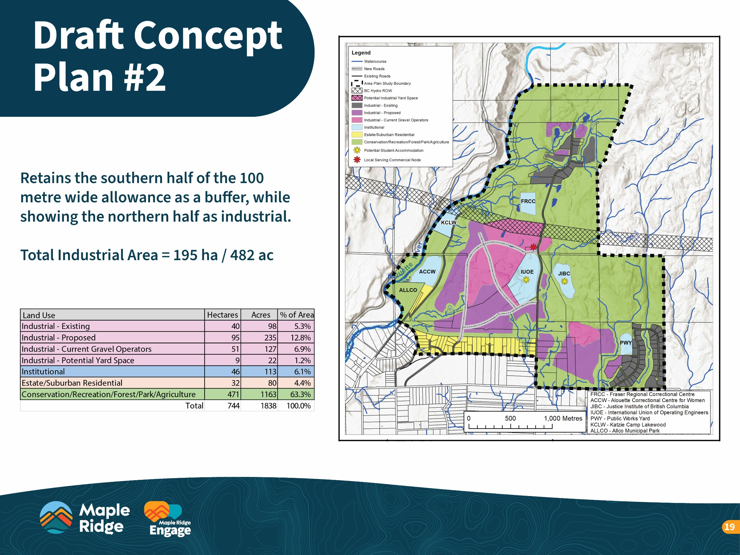
- Concept Plan 2 Splits the 100-metre allowance in half — retaining the southern portion as a buffer while using the northern portion for industrial development. This option provides slightly more industrial land while still maintaining some separation between existing residential and non-industrial areas.
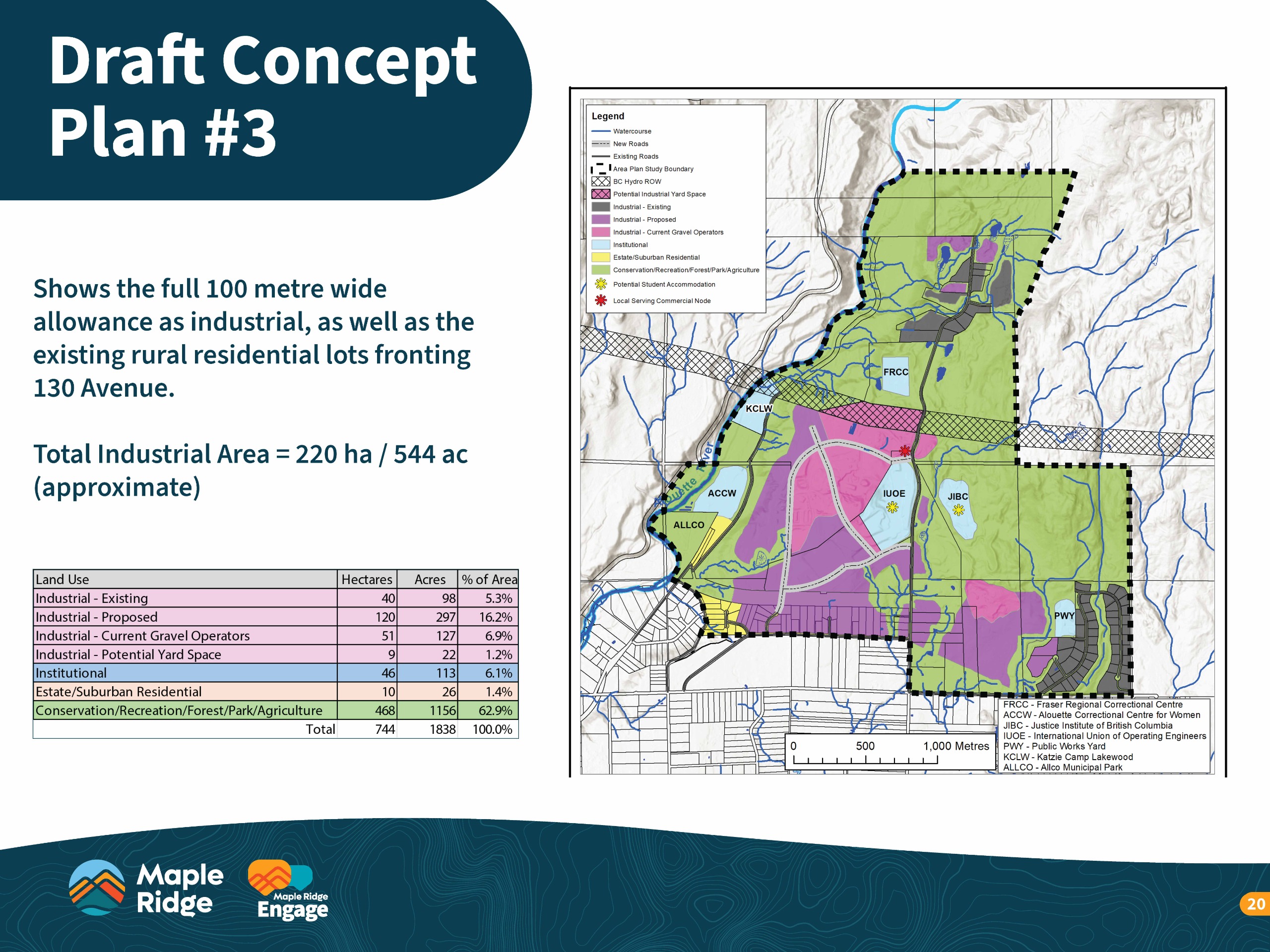
- Concept Plan 3 Shows the full 100-metre allowance as industrial and redesignates existing rural residential lots along 130 Avenue. This option delivers the greatest economic and employment benefits by expanding industrial lands but also represents the biggest land use change.
Designations indicate an intended long-term land use. Any development would be initiated by the landowner.
Engagement Level
The engagement for phase 2 was at the "consult" level of the International Association for Public Participation's (IAP2) Spectrum of Public Participation and the City of Maple Ridge Engagement Framework.
Consult: Obtain public feedback on analysis, alternatives, or decision.
Learn more about how we use the spectrum as a foundation for community engagement here.
Opportunities to Participate
Opportunities to provide feedback included a survey (available online and in print), key interest holder meetings, and an open house (see open house boards in the Document Library on this page or click North 256 St Phase 2 Engagement Display Boards).
Open House:
Wednesday, October 8, 2025
4:00-7:00 PM
Maple Ridge Public Library, Fraser Room (2nd Floor)
22470 Dewdney Trunk Road
Promotion
We promoted the engagement through the following channels: a postcard newspaper insert to approximately 3,000 residences located near the 256 St. industrial lands, a printed newspaper ad, a digital ad campaign, numerous social media posts, digital screens at City facilities, multiple emails to over 2,300 eConnect newsletter subscribers, and direct emails to interest holders.
Learnings
Feedback was received from approximately 260 survey participants, 50 open house attendees, and 20 interest holder meeting attendees.
Participants showed support for local job creation and diversifying the tax base, with some sharing concerns about traffic, infrastructure, and the environment. A graphic summary is available below and the summary report can be found here or in the Document Library section on this page.

Thank you to everyone who attended our information sessions.
As part of our Phase 3 Engagement to inform the community about the proposed updated North 256 St. Industrial Lands Area Plan, the City hosted two online information sessions for residents, industry, and other interest holders:
- Session 1: Wednesday, January 14, 12:30 – 2:00 p.m.
- Session 2: Thursday, January 15, 6:30 – 8:00 p.m.
The Information Session presentation slides are available here and in the Document Library on this page.
Engagement Level
The engagement for phase 3 was at the "inform" level of the International Association for Public Participation's (IAP2) Spectrum of Public Participation and the City of Maple Ridge Engagement Framework.
Inform: Provide the public with balanced and objective information to assist them in understanding the problem, alternatives, opportunities, or solutions.
Learn more about how we use the spectrum as a foundation for community engagement here.
Project Summary
The North 256 Street Area Plan is intended to guide the growth and development of the land, with the overall objective being to facilitate industrial land uses, while also respecting existing facilities, as well as recreation amenities, and natural features. The designation and development of the lands for industrial uses will accommodate additional business growth within the community, employment opportunities, and increase the municipal property tax base.
The North 256 Street lands will be limited to low-impact, low emission industrial uses. Heavy industrial uses will not be considered for the area.
For additional information, including area maps, benefits, and attributes, refer to the summary boards and general planning and land use Frequently Asked Questions in the Document Library on this page.
As a City Project, this project is included on the City Projects page.

Timeline
Although the duration of some components cannot be known at this time (e.g., Metro Vancouver review of amendments), the general timeline for the project is:
2025 Q1 – Start project and commence work; Develop terms of reference; Advance scope of work report to Council for approval and direction.
2025 Q2 – Public engagement and general input; Technical work; Key interest holder meetings.
2025 Q3 – Technical work; Key interest holder meetings.
2025 Q4 – Technical work; Draft land use plan.
2026 Q1 – Public engagement and feedback on draft plan; Key interest holder meetings.
2026 Q2 – Review / apply comments; Finalize draft area plan; Consideration of 1st and 2nd reading of the OCP amendment bylaw; Hold Public Hearing; consideration of 3rd reading; Refer to request Metro Vancouver for consideration of amendment and sewerage area extension.
2026 Q3 – Metro Vancouver approval, GVS&DD approval; Final adoption of Area Plan.
2026 Q4 – Commence implementation.

Background
On Feb 25, 2025 Council directed staff to prepare an area plan for the North 256 Street lands, focusing on industrial use. Council's direction included approval of the Terms of Reference and scope of work. View the Staff Report to Council and the presentation (starting at 18:57) in the Document Library and Links sections on this page.
Informed by community engagement and input, staff will be preparing the area plan, expected to be completed by late 2026. The final plan will be adopted by Council through an amended Official Community Plan and also require approvals by Metro Vancouver.
The North 256 Street Industrial Lands Area Plan will:
- Build on past City-wide studies to identify non-residential land uses with the greatest development opportunity.
- Prioritize the North 256 Street lands, given potential industrial land uses, return on investment, long-term benefits to the City.
- Align with the long-term considerations of the Official Community Plan and the Regional Growth Strategy.
Maple Ridge’s Official Community Plan establishes policies that:
- Support the facilitation of opportunities for local job growth
- Promote local business strengths to a global market
- Encourage local job creation to foster a balanced community
- Identify need for new industrial lands for future employment
- Also supportive of the Economic Development Strategy
The North 256 Street area represents a significant amount of land that could be added to the region’s industrial land supply.
Scope of Work
- Assess site constraints and opportunities
- Prepare a conceptual land use plan
- Review transportation needs
- Analyze possible servicing needs
- Refine land use design
- Prepare associated policies
- Finalize the area plan
Climate
Robust land use planning supports a sustainable and resilient economy, and an efficient transportation system reduces emissions. As part of the planning process, the subject lands will be analyzed and site-specific environmental-related matters will be identified and incorporated into a new area plan.
Infrastructure and Transportation
The Area Plan will include an infrastructure servicing and transportation network plan that addresses both on-site requirements and off-site impacts.
The area plan will address local and city-wide concerns about traffic generation, through the coordinated upgrade of road network and eventual transit service to the area.
Industry
The expected industrial uses will be relatively light, low impact, and clean, with sustainability components integrated into the area plan, as appropriate and feasible.
Environmental and Hydrogeological Overview Assessment (Nov 2025)
An Environmental and Hydrogeological Assessment was completed by Active Earth Engineering Ltd. as a key element of the preparation of the North 256 Street Industrial Lands Area Plan. The study was a high-level, area-scale assessment to identify environmental features, opportunities, and constraints. The study was used to develop the policy framework of the Area Plan and will inform the future development of the lands. It included an evaluation of groundwater conditions underlying the Study Area, analysis of riparian areas and fisheries watercourse classifications, assessment of vegetation communities and wildlife (including species at risk), identification of environmentally sensitive areas, potential wildlife corridor options, and identified potential constraints and opportunities.
All future development will require additional site-specific environmental reviews and permits. Active Earth Engineering Ltd. and the City of Maple Ridge do not accept any responsibility or liability for the use of this study.
View that report here or in our Document Library:
Environmental and Hydrogeological Overview Assessment (Nov 2025)
Translations
There is an automatic translation tool available at the top-right of this page. Languages include: Traditional Chinese [繁體中文], Simplified Chinese [简体中文] Punjabi [ਪੰਜਾਬੀ], Filipino [Tagalog], Vietnamese [Tiếng Việt], French [Français], Korean [한국어], Japanese [日本語], Spanish [Español] and more.
Please Note: Google Translate is a third-party service and we cannot guarantee the quality or accuracy of the translated content. If you require additional support, email engage@mapleridge.ca.


